Super Typhoon Sinlaku is closing in on remote U.S. territories in the western Pacific Ocean, threatening to bring extremely powerful winds, thunderstorms and widespread flooding when it barrels over the northern Marianas Islands on Tuesday, forecasts show.
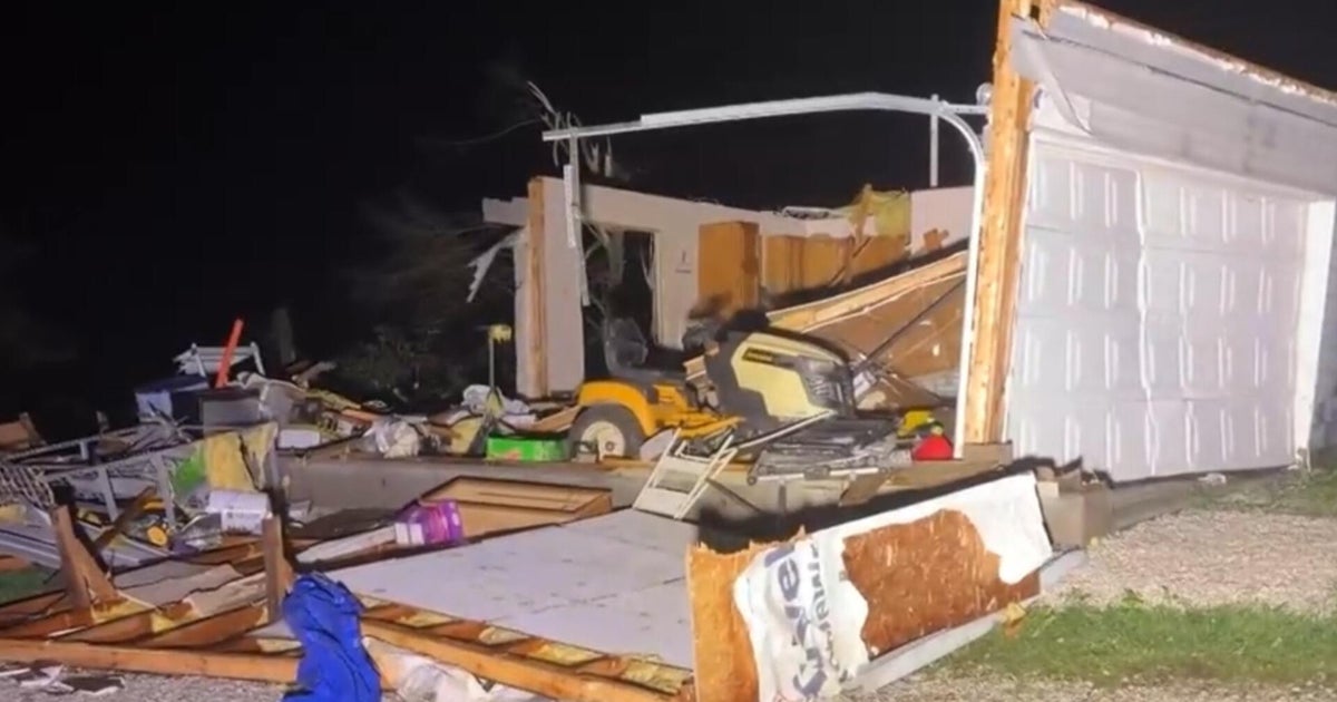
Sinlaku’s inner eyewall came ashore on the Marianas islands of Tinian and Saipan at around 10:15 p.m. local time, which was around 8:15 a.m. ET, according to the latest update from the National Weather Service office in Guam. At the time, the storm was packing maximum sustained winds of 130 mph, equating to a strong Category 4.
“As the eye moves over the islands, a short reprieve of winds and rains will occur before stronger winds on the backside of the storm move across Tinian and Saipan,” the weather service said. “Everyone should remain sheltered in place even if the winds temporarily become calm within the eye.”
Video shared by the Associated Press showed the early impacts of the super typhoon on Saipan, as Sinlaku hovered offshore, launching fierce winds and rain toward the island. Earlier in the night, the storm had become “nearly stationary” about 30 miles off the coast of the archipelago for several hours.
Home to three U.S. military bases and about 170,000 people, Guam is not expected to see a direct hit from the super typhoon. However, wind gusts of up to 80 mph have already been recorded on the island and tropical-storm-force winds were forecast to continue through Wednesday afternoon, according to Guam’s Joint Information Center.
“Even though the closest point of approach has passed, damaging winds will persist across the island, posing ongoing risks to public safety, infrastructure, and power lines,” the center said in its latest advisory, which urged people to remain indoors and out of the water.
NOAA via AP 
The Guam Department of Education closed schools Tuesday and Wednesday, and the information center said they would remain shut until the governor declares conditions are safe for classes to return. The center also said Guam’s water authority was “aware of multiple power outages throughout the island as a result of the super typhoon.”
Forecasters anticipate that Sinlaku will pass over or near Tinian and Saipan as a destructive Category 4 storm late Tuesday night in the local time zone. Typhoon warnings were in effect for the Marianas islands of Rota, Tinian, Saipan, Alamagan, Pagan and Agrihan ahead of the typhoon’s arrival, according to the weather service. Guam remained under a tropical storm warning and typhoon watch, the weather service said.
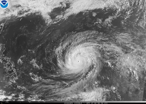
In the Southwest Pacific, “typhoon” is used to describe a tropical storm that forecasters would call a hurricane in the U.S. When a typhoon’s maximum sustained winds rise above 150 mph, it becomes a “super typhoon.”
Sinlaku’s maximum wind speeds peaked at 180 mph as the typhoon traveled over the open ocean on Sunday, making it the most powerful storm to develop so far this year, after typhoons Narelle and Dudzai.